
Engineers with Drones is an Irish-owned and Irish-based drone inspection company. We are an independent provider of UAV inspection services. This ensures our findings are completely impartial.
Our engineers are multi-skilled professionals. We have the certifications required to safely carry out drone inspections, with the expertise to interpret our findings. Every decision made throughout the inspection process is based on our technical insight. Nothing about your inspection is left up to chance.
Click here to meet our team here.
The clue is in the title: we really are engineers with drones. We believe drone pilots should know about what they are inspecting. That is why all our pilots are industry experienced. As a Specific Category drone company in Ireland, we provide inspection and technical data collection services to all sectors.

As an EASA B1 licensed aircraft engineer, Bob spent 15 years working in the aviation sector before founding Engineers with Drones. He is an expert in electromechanical equipment and control systems, and he holds qualifications in both mechanical and electrical disciplines.

Steve is a Mechanical Engineer with vast experience across various industries including wind energy, construction, marine, and oil and gas. He is a veteran of main component failure investigations, SCADA projects and technical due diligence projects.
Engineers With Drones is the first company in Ireland to hold the new EASA Specific Category authorisation. Being authorised by the Irish Aviation Authority (IAA) and the European Union Aviation Safety Agency (EASA) for commercial Unmanned Aerial Vehicle (UAV) operations in both urban and rural environments.
Specific Category Authorisation Number: IRL.UAS.AUTH1002
All our Pilots are EASA certified in the Specific Category for drone operations, trained to the highest standards, and experienced in UAV flight.
Engineers With Drones is the first, company in Ireland authorised in the Specific Category for drone operation. This gives us more freedom when flying drones. The training required to achieve this also ensures our pilots operate at a much higher grade than standard. As a specific category drone company in Ireland we can fly in places such as restricted airspace, urban environment snd over sensitive infrastructure.
Restrictions to flight can often mean the end of an inspection. Authorisation in the Specific Category minimises that risk, and allows us to be more comprehensive when conducting drone operations.
EASA Drone Authorisation Categories
Engineers With Drones is also certified to work in the UK under the UK Civil Aviation Authority (CAA) to conduct commercial Unmanned Aerial Vehicle UAV operations.
All our drone pilots are trained and certified thermographers. They are certified by Infrared Training Center (ITC).
Variations in heat can make faults apparent in an instant. We capture heat data invisible to the naked eye with a 640 x 512px radiometric thermal camera. Although often overlooked, this is an efficient way of answering almost any question you have.
Thermal cameras have applications in many situations. Anything with a temperature has information waiting to be uncovered.
All our pilots hold Global Wind Organisation (GWO) certification and are fully trained to the standards demanded by the wind industry sector.
Engineers With Drones are members of the Unmanned Aircraft Association of Ireland (UAAI). One of our co-founders, Bob, is a sitting committee member of the UAAI and regularly contributes to drone matters in Ireland.
All of our operations are insured in the EU and Globally.
We are based in Ireland. This allows us to serve you with minimal travel complications.
Being an Irish-owned and operated business, we understand Irish regulations. We are aware of the health and safety, certification, and insurance requirements on our island and are compliant with them.
Engineers With Drones offers long-term and sustainable technical expertise to your needs. Our inspection and technical services are flexible and efficient.
Engineers With Drones operates according to a comprehensive set of HSSE systems. Our core principles are mitigating risk through comprehensive assessment, and maintaining a high standard of education and training for our personnel.
Our HSSE have undergone comprehensive safety management training, and is accredited through the Institution of Occupational Safety and Health (IOSH). We are well versed in risk management principles.
Read more about our HSSE management system here.
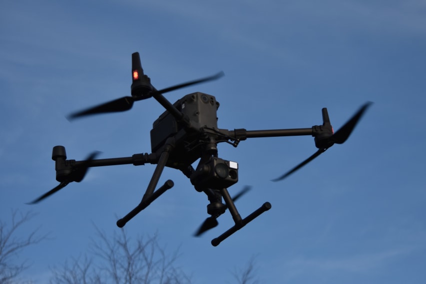
Here at Engineers With Drones, we fly the latest cutting-edge drones. Our UAVs are selected specifically for the tasks they perform. Drones such as the DJI M300 and payloads such as the Zenmuse H20T with high optical zoom lenses are optimal for safely inspecting high-value assets at a stand-off range.
To find out more about our drone equipment and what it can do click here.

We are proud to work with SquareFish.ie. They work with us on our marketing, website and digital systems. You can find out more about SquareFish here.
Optical zoom is a feature found in cameras that allows you to change the focal-length of the lens, which in turn magnifies the image. Unlike digital zoom, which simply enlarges the pixels of an image, optical zoom physically moves the lens elements to zoom in or out, resulting in a higher-quality, more detailed image.
Optical zoom is better than digital zoom for several reasons. Firstly, optical zoom maintains the image quality and sharpness because it captures more detail from the subject. In contrast, digital zoom often results in a pixelated, blurry image because it enlarges the existing pixels of an image, which degrades the quality.
Secondly, optical zoom allows you to get closer to your subject without physically moving closer, which can be useful in situations where you cannot or do not want to approach your subject closely. This can be especially helpful for wildlife photography or for taking photos of events from a distance.
Overall, optical zoom is a valuable feature that can help you capture high-quality, detailed images from a distance, making it a must-have for many photographers.
